Showing posts with label Red Rock Canyon. Show all posts

Friday, October 2, 2015

Global Peak Backway Route

Global Peak from the east
Global Peak is an obscure peak in South Red Rock Canyon. The traditional route is difficult with lots of elevation gain and class 3+ scrambling. A leader of the 52 Peak Club found a much easier route from the west via the backway to Windy Peak.

It's a fun route, but not easy to follow and not intuitive.  I created the below video to help hikers follow the route.


Monday, November 11, 2013

4 Reasons to Join the 52 Peak Club


1. You will get into better shape.
If you hike/climb all 52 Peaks, it's impossible not to get into better shape. Why? By climbing all 52 Peaks you will have ascended over 120,000 feet, which is the equivalent of climbing 8,000 flights of stairs. Also, you will have walked/hiked over 300 miles.
Another reason you will get into better shape is rock scrambling uses all of your muscles and is not the same repetitive motion as swimming, biking, or running.

2. You will conquer your fears and increase your self confidence.
When you hike/climb all 52 Peaks, your fear of heights will be conquered. Many people have a fear of heights. This will give you self confidence that you can use in other areas of your life.

3. You will learn about the peaks and more about hiking.
The 52 Peak Club has the best leaders that can teach you about the different peaks and general hiking information. Your knowledge in any subject is directly related to who you listen to, be it a person, book, DVD etc.

4. You will meet some great people.
The 52 Peak Club attracts people who want to better themselves. These are people who set goals and achieve them. Not only will you meet them; you will get to know them. Our average hike is about five hours. You can get to know someone pretty well in five hours and that's just one of at least 52 hikes you will do.
We have females and males; ages from 18 to 75; and people from all over the world are members of the 52 Peak Club.

                                       Join now and take your hiking to the next level.

Friday, June 24, 2011

Great Red Rock Summer Hike

Yes, the temperature is in the triple digits now, but you can still hike in Red Rock if you know the secret.
What's the secret? Watch the video!
Now you know the secret!
But can you follow the route to Boot Boulder? You can if you are a member.
More information about become a member: http://www.hikinglasvegas.com/PreviewPage.htm

Thursday, April 7, 2011

Red Rock Canyon Will Close if Government Shutdown Occurs

What does this mean? As of Friday April 8th, 2011, the federal government is schedule to shutdown as I write this. If this occurs, Red Rock Canyon will close the Scenic Loop Road.
How will this effect you?
Only hikes that start along the Scenic Loop will be closed to cars. This means you would have to walk in from State Route 159, not a good alternative.
Calico Basin parking area would be closed, but you can park outside the gate, so that's no big deal.
Kraft Mtn parking area would probably be closed, but you can park outside the gate, so that's no big deal.
First Creek parking area will most likely be open.
South Red Rock should also be open.
Bottom line: Hikes along the Scenic Loop would require a very long walk in and out. Best to hike at First Creek, South Red Rock, or Calico Basin until the government reopens.

Monday, January 24, 2011

Death Valley and Various Updates

On Saturday, January 22nd, nine hikers took a day trip to Death Valley. We hiked through Golden Canyon to Zabriskie Point, one of the best easy hikes in Death Valley. This is an extremely scenic hike with great views all the way down to the desert floor. Along the way you pass Manley Beacon, a prominent highpoint composed of dirt and clay.


After the hike we drove to Badwater, the lowest point in the United States (-282 feet below sea level). Many times as I drove to Badwater it looked like there was water, but it was a mirage. However, this time there was water. It looked like an ocean!
Check out the video below.


We then drove up to Dante's Point, which towers  5,000 feet above Badwater. The panoramic views of Badwater and beyond were amazing.


Updates:

The road leading to Lovell Wash, which leads to Anniversary Narrows has been repaired. Recent rains washed the road out leaving a four foot drop! The repair was done quickly.

I was told the Rockey Gap Road will be repaired by the end of the month. Again rains made it almost impassable to virtually all vehicles.

There's still ice on some north facing routes in Red Rock. Be careful!

Thursday, December 30, 2010

Best Winter Hikes in Red Rock

A few years ago I and others realized there was a great need to find routes in Calico Basin.Why? Since most of these routes are east facing and none of them reach high elevations, they would be the first routes to be free of snow and ice.

Many of these routes are scrambling hikes, so you need to wait at least 24 hours after it rains and even longer if snow is melting. Normally it does not take long for snow to melt in the Calico Basin area. However, you must be careful of rock breaking.

Here's a list of hikes in the Calico Basin/Kraft Mtn. area:

Calico Tank Peak East Face route
Calico Tank Peak Red and White route
Turtlehead Jr./Red Cap Double Slot route
Calico Hills Loop
Calico Hills Traverse
Kraft Mtn Loop
Kraft Mtn. Up and Across
Kraft Mtn. Up and Over
Kraft Mtn. East route
Twin Tanks
Gray Cap Peak

All of these hikes are relatively short and most have lots of scrambling. Since all of these hike start in Calico Basin there's no entrance fee and no driving the Scenic Loop!!!

The Kraft Mtn. East route hike is new. It has some fun scrambling and avoids loose rock. I believe this is the best route on the mountain.

Members of HikingLasVegas can download all of these hike descriptions plus another 350.
For more information, Click Here

Monday, December 27, 2010

Red Rock Canyon - Hiking Coming to an End - Lake Mead Hikes Starting


With the forecast for temperatures in the low 40's for Vegas, Red Rock will have lots of ice due to all the rain. I do not recommend any scrambling hikes once the cold weather sets in. Instead I would head out to Lake Mead area. It's always warmer out there and almost never has ice or snow.


Here are some of the better Lake Mead Hikes:

Although the peaks around Lake Mead are not high, they do offer some nice views. There's no death defying scrambling or crowds.

Challenge: Can you name all seven peaks in the photo above? 

Saturday, December 25, 2010

Status of Red Rock Canyon

As of yesterday (12-24) the Scenic Loop Drive was opened, but the following areas were closed:

  • The gravel road to Keystone Thrust Trailhead.
  • All of Willow Springs.
  • The gravel road to Oak Creek Trailhead.


With the chance of rain tomorrow (12-26), I can only guess if those areas along the Scenic Loop Road will be open.

Mt. Charleston has received over two feet of snow in the last 48 hours. All roads are opened as I write this.

Wednesday, December 22, 2010

Once in a Lifetime Flood at Red Rock Canyon!

This is the most rain I have ever seen in the 27 years I have lived in Las Vegas. Yesterday (12-21), I hiked into Oak Creek Canyon. I have never seen so much water. The video below tells the story. It would be impossible for anyone to hike through the canyon. It really was a river.

Red Rock Canyon will remained closed at least through today. You can't even drive to the fee booth -- it's blocked by a gate. Yesterday SR159 was closed before Calico Basin, so you couldn't even drive into the basin. As I was driving south on SR 159 toward SR 160, it looked like they were closing SR 159 near the intersection with SR 160. IOW, there's no access to Red Rock Canyon. I also believe they can close the road into Black Velvet Canyon via a gate. I will keep you updated as to when Red Rock will reopen.

The forecast for today is calling for at least 0.50 inches of rain and up to one inch is possible. To give you an idea of how much rain that is Las Vegas normally receives four inches of rain in a one year period! Vegas might get 25% of its annual rainfall in one day.

All roads in Mt. Charleston are also closed as I write this.

WordPress plugin


Sunday, October 17, 2010

REI Traverse 30 Pack


It was time for a new daypack. I wanted to go with something a little smaller for tight chimneys and slots in Red Rock Canyon. REI has a sale and I really liked their Lookout 40 pack, but it's big for Red Rock. I bought the Traverse 30 pack instead.

It's less expensive than the Lookout 40, a little narrower (big plus), slightly lighter and has several key fobs. With six pockets it's easy to stay organized. It even has a pocket in the waist-belt for easy retrieval of small items, plus a built in rainfly!

I wore it on a hike to Decision Peak in Red Rock Canyon. This is a moderate scrambling hike with some tight squeezes. I did not hear it scrape against the sandstone like larger packs I have worn.  Also I did not feel it extended backwards too far. Since it is smaller I can't fit as much gear into it keeping the size and weight down.  Overall I was very impressed with the pack and would recommend it.

Thursday, September 23, 2010

Red Rock Issues


Well, it's getting interesting. In a poorly written press release on 9-18-2010, the BLM stated The Scenic Loop would close three hours earlier than normal starting on 9-20-2010, a whopping two day notice!!! Here's the exact wording:

Release Date: 09/18/10 
Contacts: Kirsten Cannon , 702-515-5057 , kirsten_cannon@blm.gov

Red Rock Canyon Scenic Drive Hours to Change

Las Vegas – Beginning September 20, the 13-Mile Scenic Drive at Red Rock Canyon National Conservation Area will close at 5 p.m. The gates will still open at 6 a.m. 

The closing time of the scenic drive is adjusted seasonally based on daylight and visitation. 

All other closing times at Red Rock Canyon will remain the same. The Red Rock Overlook on State Route 159 and Red Spring will be open from 6 a.m. to 7 p.m. through October 31. The visitor center is open from 8:30 a.m. to 4:30 p.m.

This obviously created an uproar from hikers, runners, walkers and bicyclists.  What the press release did not state was: Cars and visitors already on the Scenic Loop (everyone calls it the Scenic Loop, except the BLM) will not have to exit until the normal closing hours, which is currently 8 p.m.  If these geniuses would have included that fact, there would not have been such an uproar. The new policy is still wrong, but not as restrictive as the press release made it sound.

When we all called Kirsten Cannon about this, guess what? She is gone and will not be back until 9-28-2010 according to her voice mail. It so obvious what's going on.

So why did the BLM decide to close Red Rock three hours early just as prime hiking season is upon us? I am not going to tip my hand, but I am pretty sure I know the real reason, not the pathetic reason the BLM stated.

Yesterday a friend called me and said the gate at the start of the Scenic Loop was opened after 5 p.m. The fee booth was unmanned. That's about as much as an about face as I have ever seen. In one day the BLM went from restricting access to granting free access. Wonder what is going on? Let's just say there's a heat wave at 4701 North Torry Pines and that puts a big summer grin on my face.

Keep the pressure on the BLM by writing to the following politicians:


Dina Titus' liaison is Susan Petersen (387-4941). Email: susan.petersen@mail.house.gov

Shelley Berkley's liaison is Tod Story. Email: tod.story@mail.house.gov.

Senator Reid: http://reid.senate.gov/contact/index.cfm

Senator Ensign:
http://www.ensign.senate.gov/public/index.cfm?FuseAction=Contact.ContactForm

Focus on these three issues: Access, Visitor Safety and Irresponsible Spending of Taxpayer's Money
Believe me writing to the above politicians is working!!!


Monday, September 20, 2010

Bees at the Mouth of First Creek Canyon


On Sunday as we worked our way past the plethora of spur trails that lead into First Creek Canyon seven hikers were stung by African bees! The photo shows exactly where the bees were. This is just before the Cottonwood tree that marks the end of the path and the start of the wash through First Creek. Although I was not stung, those who were said the bees were aggressive, a trait of African bees.

As many know you pass this point to hike to Mt. Wilson, First Creek Peak and Decision Peak. There are also African bees along the class 3-4 climb on the route to Tunnel Vision Peak.

The Solution:
The original route follows a path to the right of the boulders. It's somewhat overgrown now, but still followable. We took this path on the way out and did not disturb the bees.


My Rants: There are so many paths into First Creek it's impossible to know which is the best path. The environmental nuts at Red Rock cry about trail braiding, but then are too lazy to build one decent trail into the canyon.

Do you think for one second you will see anything on the BLM's pathetic website about the African bees? Since the rangers don't hike, how could they know about the African bees?

Tomorrow: I will address the issue about the new closing hours at Red Rock Canyon. I am waiting for some more inside information.

Tuesday, June 22, 2010

Mt. Charleston vs. Red Rock

Sounds like an old-time monster movie! Luckily in this match up both areas are winners. We are lucky here in Las Vegas to have two very different hiking areas so close; however, there are big differences.

Terrain:
Red Rock - Sandstone                                    Charleston- Limestone
Elevation:
Red Rock - 3,700 to 7,070 feet                      Charleston ~7,000 to 11,918 feet
Season:
Red Rock - Spring, autumn and winter           Charleston: Summer
Hours:
Red Rock - 6 am to dusk                               Charleston: 24 hours
Fees:
 Red Rock - $7 per car                                  Charleston: No fee to enter
Number of peaks:
 Red Rock - 50+                                           Charleston: 19
Snakes:
Red Rock - Yes                                             Charleston: Yes, but not venomous
Managed by:
Red Rock - BLM                                          Charleston: US Forestry
Type of hiking:
Red Rock - trails and scrambling   Charleston: trails and mountaineering

I have alway felt Red Rock is more of a full body workout than Charleston, but it beats you up more.
Charleston is a better cardio workout, since it's at elevation and the hikes are longer.
From talking with hikers and polls on my website, most hikers prefer Red Rock hikes.

Do you have a preference and why? Leave a comment.

Sunday, June 13, 2010

Cold in Red Rock in the Middle of June!

WordPress plugin


The title sounds crazy and probably gets your attention, which is good. I have been following an interesting weather trend for the last 14 years. For 13 out of the last 14 years for a few days in June the temperature drops drastically. Yesterday (6-12-2010), the high in Las Vegas was 79. That's 20 degrees below the average high for June 12th. Wow! This emphasizes an important point: keep track of the weather forecast. Forget about the season. Normally it's too hot to hike in Red Rock during June. By keeping track of the weather forecast I knew it would be plenty cool to get in one last hike in Red Rock. I also knew there was a chance of rain so we were prepared. Since it was cool, we wore polypro instead of cotton. You do not want to wear cotton when it's cold.

I chose the Bridge Mountain official trail.  In my opinion the Bridge Mtn Trail is the best official trail in Red Rock Canyon. It's well marked and very easy to follow. The trail ends well before the summit, but travels just west of an incredible overlook into Pine Creek Canyon. Unfortunately, the trailhead is a five mile drive up the Rocky Gap Road, which requires a decent 4-WD vehicle. You can drive about 2.4 miles in a high clearence vehicle and then walk to the start of the official trail.

We started hiking around 11 am with overcast skies. I am guessing the temps were in the mid fifties. The trailhead starts at almost 6,400 feet, some 4,000 feet higher than Las Vegas. About a half mile up the trail it started to rain hard enough to put on our rain gear. I had an emergency poncho which kept me dry and fairly warm. They are very lightweight an inexpensive. It's something every hiker should carry in their daypack.

Once we reached the ridgeline the wind picked up enough that we were all glad we had multiple layers on and not cotton. We continued on the trail as the rain diminished to a mist. We soon reached the overlook where you get your first view of Bridge Mountain. I figured with the rain and wind it felt like the temperature was in the low 40's at the overlook.

There's several spots to sit and look down over 1,500 feet into Pine Creek Canyon. Although I have scrambled through Pine Creek to the summit of Bridge Mountain the route looks impossible from the overlook. You can see all the way from Bridge Mtn to Mt. Wilson. This is one of the best views in Red Rock. I highly recommend this hike.

Here are the stats:
Difficulty: 2 (out of 5)
Distance: 4.5 miles - round trip (starting from the official trailhead)
Elevation gain: 1,400 feet
Highest point: 6,900 feet
Time: 2 hours (round trip) + time spent at the overlook

Note: This overlook is a little south of the overlook at the top of Piuate Wall and I feel it's better.
Members can download this hike now. Not a member? Learn more about becoming a member here.

WordPress plugin

Saturday, March 27, 2010

The Route to Mt. Wilson


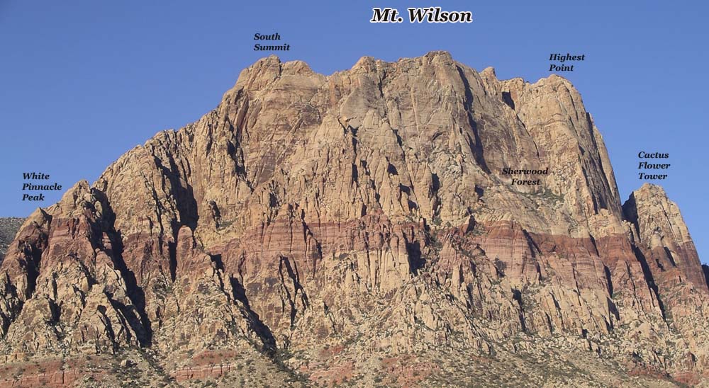
Mt. Wilson is one of the crown jewels of Red Rock Canyon, which is only 20 miles west of Las Vegas, NV. There are many peaks on the massive mountain. This hike description travels to the true summit, which soars 7,070 feet into the air. This is the standard route through First Creek Canyon and technically the easiest.

The Hike Description:

Hike: Mt. Wilson via First Creek Canyon — route
Trailhead: First Creek — marked
Distance: 10 miles – up and back
Elevation gain: 3,400 feet
Elevation of Peak: 7,070 feet
Time: 7 to 9 hours (up and back)
Difficulty: 5
Danger level: 3
Class: 3
How easy to follow: 3
Children: No
Waypoints: (WGS-84) See Page 10
Fees: None
Best Season: Spring and autumn
Driving directions: From the Mirage on Las Vegas Boulevard (the Strip) go north three miles and turn left (west) onto Charleston Boulevard. Drive 21 miles on Charleston (it becomes State Route 159) to the signed First Creek parking area on the right (west) side of the road. You’ll drive past the entrance to Red Rock Canyon. Do NOT turn into Red Rock Canyon. Waypoint 1 is the trailhead. Photo 1 is Mt. Wilson.
The hike: Follow the signed trail toward the mouth of First Creek Canyon. When it forks, take the left (south) fork. Rocks block the right fork. In about a quarter of a mile, the trail goes down a hill and passes under a branch of a 20-foot scrub oak (Waypoint 2). From this point the trail divides into numerous paths. Follow any path that stays near the creek. You will always be to the south (left) of the creek. Just before the path enters the creek, take the south (left) fork, which climbs a hill. (Waypoint 3.) At the top of the hill, the path merges with other paths. Continue west toward the canyon. The path divides at a 20-foot juniper (Waypoint 4). Follow the north (right) fork down a hill. At the bottom of the hill, a log has fallen across the path. Eventually the path goes across a band of red sandstone. About 15 feet after the path changes back to dirt, it forks. Take the north (right) fork (Waypoint 5). Actually if you continue straight, you encounter massive brush.

The path weaves between two boulders and then heads west (left) into the canyon. Numerous cairns help keep you on course from here to the wash. Follow the path through the brush to a large low-angled boulder. Scramble up the boulder and continue on the path. A row of rocks outlines the path as it heads north to the wash. Continue on the path to the large Cottonwood tree (Waypoint 6) in Photo 2. The Cottonwood tree can look much different depending on the season. You’re finally in the wash.
To continue reading click here.

Wednesday, March 24, 2010

Updates: Five Hikes in Eight Days

I am updating hikes almost on a daily basis. The rain and snow has done a lot of damage to the canyons. We have cleaned the routes, re-cairned them, and I have added lots more photos and waypoints to the route descriptions. Here's a list of the hikes that have been updated: Fern Canyon - level 1; Bridge Point - level 5; Ice Box Canyon Overlook - level 3; Calico Traverse - level 2 and Bridge via Pine Creek - level 5.

Bridge Mtn and Bridge Vista
Today I am off to hike Mt. Wilson via the standard route through First Creek and I will be updating that route description. Do you think any other website updates their route descriptions like I do?

To download and print out the hikes I have updated, click here.

Saturday, March 13, 2010

Where to Hike When It's Windy

It's windy today (3-13-2010). So where do you hike? Red Rock and here's why: Lake Mead is very open and gets more wind. Charleston will be cold. While hiking in Red Rock stay off ridges. Stick to the canyons; they offer more protection from the wind.
 
Coming soon: Free Screensavers to download. I have over 28,000 photos, so naturally I have a few good ones. I am creating screensavers for people to download. I think you will like them. Here’s one of the photos.


Branch - Your Online Hiking Guide

Friday, October 9, 2009

My Favorite Short Hikes in Red Rock Canyon


So you only have a few hours and you want to go for a hike. We all know driving the Scenic Loop at Red Rock Canyon takes time, so instead do a hike out of Calico Basin. This will cut the driving time by 75%.
Here are my favorite hikes out of Calico Basin area: (Calico Basin is two miles before the turnoff to Red Rock Canyon)


Kraft Mountain - Up and Down the Backside (2 - 3 hours)
Kraft Mountain Loop - (2 hours)
Turtlehead Jr - Double Slot Route (3 hours)
Calico Tank - Red and White Route (2.5 hours)

All of these are fun scrambling hikes. The Double Slot route to Turtlehead Jr is one of my favorite hikes in Red Rock! Of course, all of these routes can be found in the Members Only section of my web site.

Did you know Google Ads are at best confusing and can be dangerous. Many web site owners place Google Ads in such a way to make you think they are part of the web site. When you click, you are taken to another web site. But it gets worse. Criminals are signing up for Google Ads. When you click on their ads, your computer will get infected or your personal information might be stolen.
Guess what web site does not have Google Ads? Yes, www.hikinglasvegas.com. NO confusing ads and safe.
To be fair Google is working on the problem, but it will be sometime before they can eliminate the unsafe ads.

Tuesday, December 23, 2008

New Slide Show of Red Rock Canyon

Over the last few days I have been in Red Rock Canyon, just 20 miles west of Las Vegas, taking photos of the snow. I took some good photos and found a really cool slide show to present the images. Click here to view the slide show. Enjoy!

Wednesday, October 8, 2008

Red Rock Hiking Tips


This is the time to hike and scramble in Red Rock Canyon. Here are some tips to make your hike more enjoyable:

* Work on your balance at home or at the gym. Many routes in Red Rock require good balance.
* Wear sweat pants to protect your legs from brushy routes. The brush will eventually tear your pants. Why wear expensive pants when you know they will get ruin?
* Wear gloves. The brush and terrain are tough on hands.
* Do the longest routes now while there's more daylight and the Scenic Loop stays open until 7 pm.
* The Member's Only Section (on this web site) is the ultimate resource for Red Rock hiking. Many of the routes are virtually impossible to follow without a route description.