
The Hike Description:
Hike: Mt. Wilson via First Creek Canyon — routeTrailhead: First Creek — marked
Distance: 10 miles – up and back
Elevation gain: 3,400 feet
Elevation of Peak: 7,070 feet
Time: 7 to 9 hours (up and back)
Difficulty: 5
Danger level: 3
Class: 3
How easy to follow: 3
Children: No
Waypoints: (WGS-84) See Page 10
Fees: None
Best Season: Spring and autumn
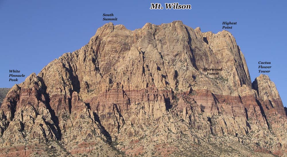
Driving directions: From the Mirage on Las Vegas Boulevard (the Strip) go north three miles and turn left (west) onto Charleston Boulevard. Drive 21 miles on Charleston (it becomes State Route 159) to the signed First Creek parking area on the right (west) side of the road. You’ll drive past the entrance to Red Rock Canyon. Do NOT turn into Red Rock Canyon. Waypoint 1 is the trailhead. Photo 1 is Mt. Wilson.
The hike: Follow the signed trail toward the mouth of First Creek Canyon. When it forks, take the left (south) fork. Rocks block the right fork. In about a quarter of a mile, the trail goes down a hill and passes under a branch of a 20-foot scrub oak (Waypoint 2). From this point the trail divides into numerous paths. Follow any path that stays near the creek. You will always be to the south (left) of the creek. Just before the path enters the creek, take the south (left) fork, which climbs a hill. (Waypoint 3.) At the top of the hill, the path merges with other paths. Continue west toward the canyon. The path divides at a 20-foot juniper (Waypoint 4). Follow the north (right) fork down a hill. At the bottom of the hill, a log has fallen across the path. Eventually the path goes across a band of red sandstone. About 15 feet after the path changes back to dirt, it forks. Take the north (right) fork (Waypoint 5). Actually if you continue straight, you encounter massive brush.
The path weaves between two boulders and then heads west (left) into the canyon. Numerous cairns help keep you on course from here to the wash. Follow the path through the brush to a large low-angled boulder. Scramble up the boulder and continue on the path. A row of rocks outlines the path as it heads north to the wash. Continue on the path to the large Cottonwood tree (Waypoint 6) in Photo 2. The Cottonwood tree can look much different depending on the season. You’re finally in the wash.
To continue reading click here.
![]()
No comments:
Post a Comment